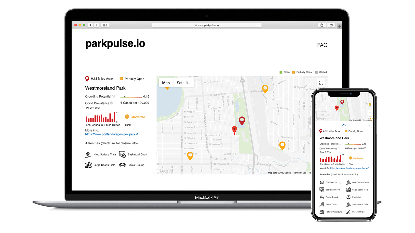
This public web resource provides visitors with a unique and comprehensive set of information about parks and natural areas in Oregon, including crowding potential, COVID-19 risk, amenities, and use restrictions.
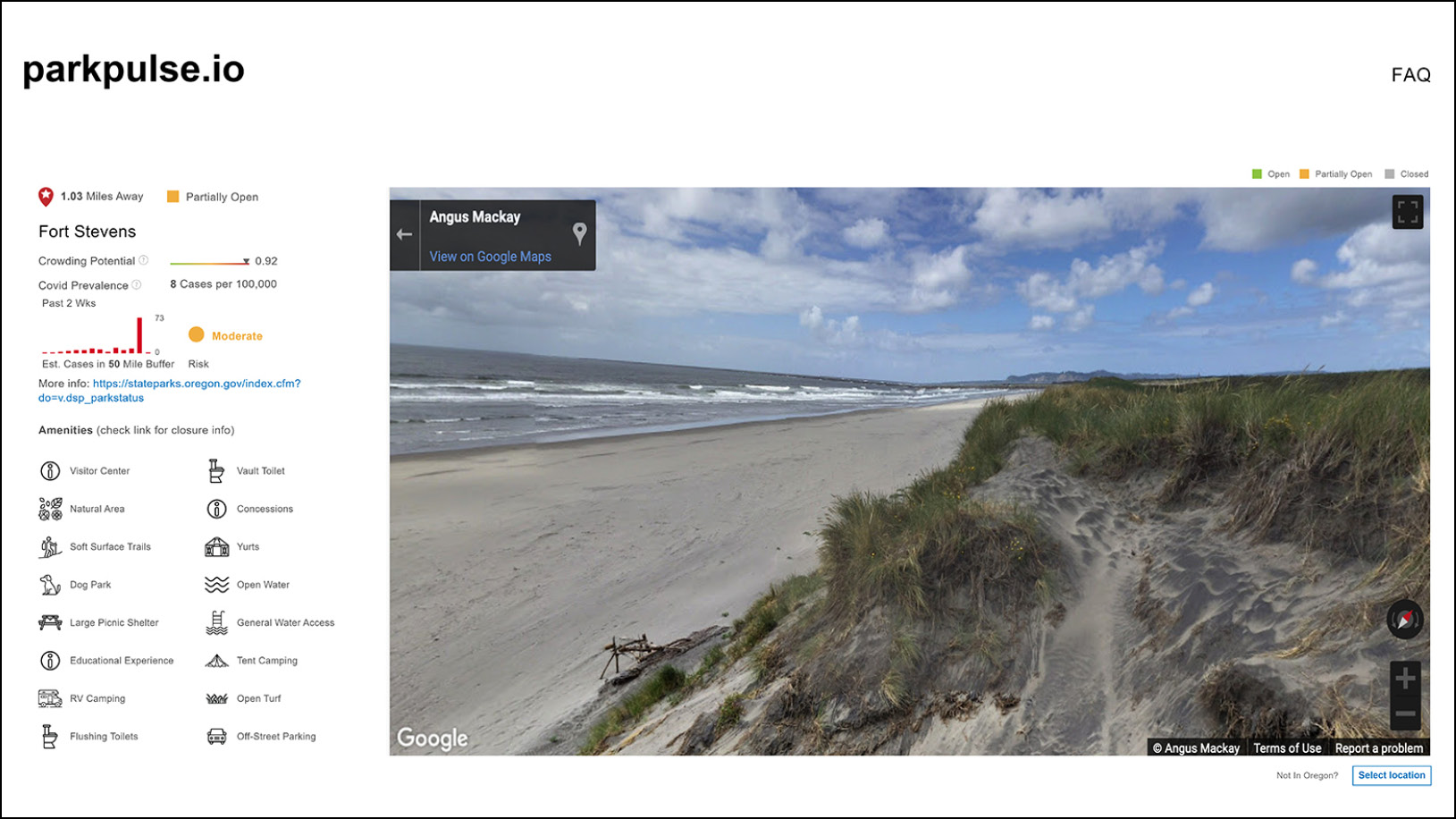
Ft. Stevens State Park
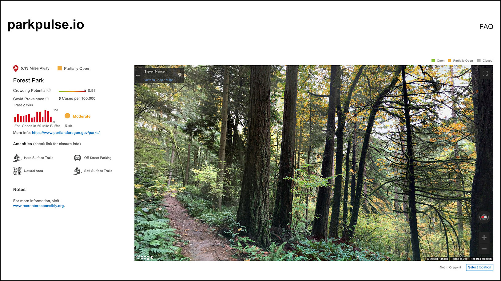
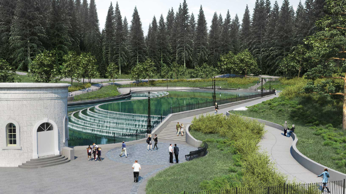
Forest Park
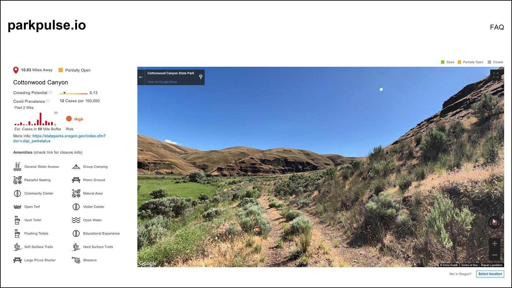
Cottonwood Canyon State Park
Introduction
parkpulse.io is designed to support safe and equitable access to parks and nature by empowering users with detailed location-specific park information for making recreation choices. Parkpulse aggregates information from over 7,200 parks and recreation points and returns a user-specific set of data based on location. For each outdoor recreation destination, Parkpulse displays available amenities, current use restrictions, crowding potential and an estimate of Covid-19 prevalence. By presenting this complex array of information in a simple but powerful decision-making interface, this site has the potential to help our community make better, safer decisions when planning to recreate outdoors.
* The New York Times COVID-19 dashboard on GitHub is no longer being updated, including the data that the parkpulse.io API references for the COVID Risk and Prevalence metrics. These metrics on parkpulse.io should now be considered obsolete.
An Unmet Community Need
Early in the pandemic Knot realized that our state and local agencies would face disproportionate and overwhelming challenges during this crisis and decided to use PPP loan money in part to fund public service efforts. Knot initiated conversations with dozens of public agencies to assess need and find interested partners. The State of Oregon Parks and Recreation Department and Office of Outdoor Recreation expressed interest and identified a comprehensive, public facing web resource that provided current information to potential users as their highest priority. Knot assembled a team, which included coding experts and graduate students in the Landscape Ecology, Perception and Design Lab at the University of Michigan’s School for Environment and Sustainability, and delivered the project pro-bono to the people of Oregon.
Assembling a Comprehensive Dataset
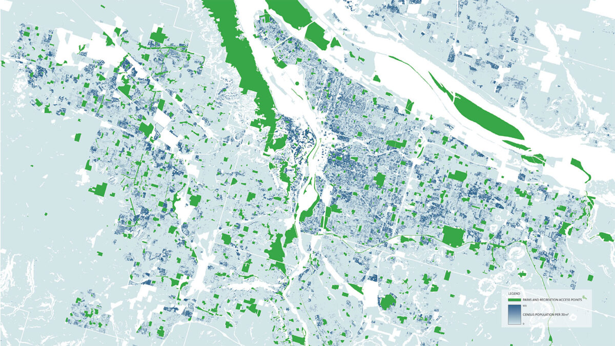
While management of outdoor recreation resources is fundamentally siloed, the experience of the user is not; people generally seek outdoor recreation opportunities based on desired experiences and don’t differentiate potential destinations based on managing agencies. Providing comprehensive and aggregated information on potential destinations in an interactive user-friendly format therefore represents a deep and previously unmet need. This need is heightened during the global pandemic when agencies are facing extraordinary management challenges, use of outdoor recreation is increasing and risks from crowding remain real.
The custom dataset which was built to power the website represents one of the most comprehensive interagency outdoor recreation datasets available in the state. Parkpulse is built on a GIS database derived in part from the Oregon Parkland Mapping Project[i], which was an initiative of Oregon Parks and Recreation Department’s 2019-2023 Statewide Comprehensive Outdoor Recreation Plan[ii]. Parkpulse incorporates parks and recreation point features under federal ownership, such as USFS, NPS, BLM, and USFWS, as well as private entities like the Nature Conservancy, adapting all features into one dataset with a consistent and comparable array of amenities and characteristics. Knot then correlated the statewide data with Google Place ID data, which facilitated the development of an agency-agnostic measurement of crowding potential. The resulting compiled dataset contains information from over 350 public and private owners and each point has over 100 attributes along with validated links to the Google Place ID dataset.
Uncovering Underutilized Local Gems
Awareness of nearby recreation opportunities and an understanding of what amenities they offer is a key to increasing the use of underutilized resources. The difficulty of accessing information about lesser-known recreation sites can exacerbate the growing tendency of high-profile parks becoming over-burdened and over capacity. In turn, built infrastructure and ecological resources maintained by budget-limited agencies suffer. The quality of user experience is markedly reduced, and from a public health perspective, some high-profile parks could contribute to the transmission of novel pathogens such as Covid-19. Additionally, the public health crisis caused by the pandemic has encouraged people to focus on localizing their use of public space to decrease intercommunity transmission of disease.
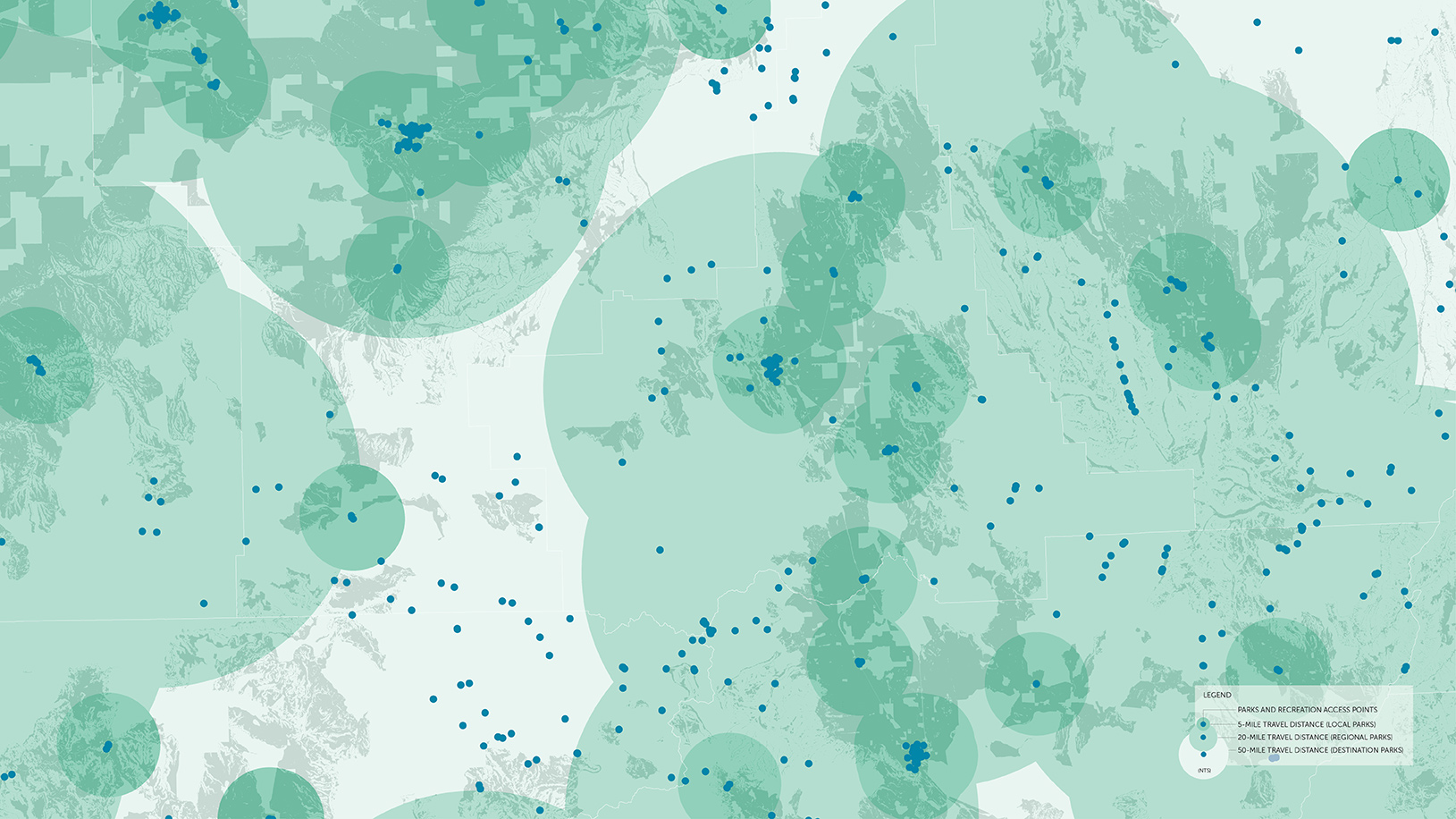
With both of these goals in mind, Parkpulse is designed to display a custom set of outdoor recreation opportunities based on the users shared location. Neighborhood parks display within five miles, regional parks within 20 miles, and destination parks within 50 miles. The maximum 50-mile distance was determined by the travel distance recommended by Oregon’s Phase 1 Reopening plans released by Governor Kate Brown in May, 2020, but also aligns with a reasonable travel range for non-overnight trips.
Spatializing Covid Risk
The current standard for Covid-19 case tracking in the US occurs at a county level. This unit is valuable for making policy decision and estimating risk for certain types of activities but when a destination has a draw that aggregates visitors from multiple county origins, like a popular State Park for example, looking at county level data doesn’t adequately reflect the true risk. In order to resolve this issue, Parkpulse takes daily county-level case counts, as reported by the New York Times[iii], and spatializes them based on a dasymetric population allocation raster. This is a technique developed by the Environmental Protection Agency and made available in their EnviroAtlas toolbox[iv], which projects census population data onto a 30m raster surface using the National Land Cover Database (NLCD). Parkpulse then reaggreagates the daily prevalence data based on total population from various counties within likely travel radii for each point and normalizes it per 100k individuals. This normalized daily prevalence information is then classified based on the Harvard Global Health Institute’s Covid-19 risk thresholds[v] to determine the overall risk for each site. The resulting value is a park-specific blended estimate of risk for each park based on adjacent population.
Estimating Potential for Encountering Crowds
Encountering crowds at outdoor recreation destinations is a challenge for both public land managers and visitors alike. For land managers crowded conditions can lead to resource degradation and the over burdening of staff. For visitors, crowded conditions lead to a reduced quality of experience and, during the pandemic, an added risk for Covid transmission. Understanding the potential for sites to become crowded is an important decision-making factor for both managers and visitors but predicting crowding potential across an extremely diverse portfolio of sites is a challenge.
Parkpulse utilizes customized combination metrics to predict the overall potential for crowds at each site. These metrics compare relative popularity against infrastructural and spatial capacity. Park features in the original state dataset were correlated to Google Place ID’s in order to arrive at a unified estimate of relative popularity that could transcend the limits of each agency’s idiosyncratic visitor use data. Park capacity was then approximated using a weighted index which evaluates park area by use type and the overall diversity of amenities available. Parkpulse then compares the capacity of the site to its relative popularity to calculate an estimated index of crowding potential for the site.
By providing these metrics in a user-friendly public facing mapping tool, recreation users will be able to make informed decisions when trip planning, ensuring that they have the tools available to avoid crowds, reduce site impacts and avoid public health risks long before pulling into the parking lot of an over-crowded site.
Broader Applications
It is widely recognized that for the foreseeable future, the earth will continue to become more crowded, ecosystems more fragmented, and that the threats we face will be unlike those of the past in their complexity and immensity in space and time. Public resources will become more valuable, and more contested. Science-based models that leverage today’s massive computing power will have a critical role in mitigating these threats, where market forces, political will, and institutional expertise alone are inadequate. Community-oriented projects that, like Parkpulse, are driven by collaboration and experimentation, offer a model for public-private partnerships that promote healthy futures.
[i] Oregon Parkland Mapping Project: https://www.arcgis.com/apps/webappviewer/index.html?id=d15b063126e247979d8c78d8a26adca6
[ii] Oregon Parks and Recreation Department. 2019. Outdoor Recreation in Oregon: Responding to Demographic and Societal Change (2019-2023 Oregon Statewide Comprehensive Outdoor Recreation Plan) https://www.oregon.gov/oprd/PLANS/Pages/SCORP_overview.aspx
[iii] The New York Times COVID-19 data: https://github.com/nytimes/covid-19-data
[iv] Pickard, B. R., Daniel, J., Mehaffey, M., Jackson, L. E., & Neale, A. 2015. EnviroAtlas: A new geospatial tool to foster ecosystem services science and resource management. Ecosystem Services, 14, 45-55. https://www.epa.gov/enviroatlas/dasymetric-toolbox
[v] Harvard Global Health Institute: Key Metrics for COVID Suppression. https://globalhealth.harvard.edu/key-metrics-for-covid-suppression-researchers-and-public-health-experts-unite-to-bring-clarity-to-key-metrics-guiding-coronavirus-response/
[vi] Centers for Disease Control and Prevention: Considerations for Events and Gatherings. https://www.cdc.gov/coronavirus/2019-ncov/community/large-events/considerations-for-events-gatherings.html